|
Remote Sensing Group. |
|
University of Lethbridge |


|
There are potential graduate school and other opportunities for qualified and motivated individuals including Masters, Doctoral, Post-Doctoral and other staff posts. |
|
This project involves airborne, satellite, and ground based remote sensing techniques to evaluate riparian zone health, vegetation composition and structure. |
|
Description 3 |
|
Description 5 |
|
Description 4 |
|
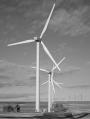
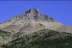
Topoclimatic indices are an efficient means of modelling these important landscapes. Using detailed ground measurements, accurate models of hydrological and biological composition are derived. |
|
Riparian Remote Sensing |
|
Project name 4 |
|
Project name 5 |
|
Project name 3 |
|
Topoclimatic Indices / Mountain Terrain Analysis |


|
Graduate Opportunities |