May 26/2010 |
Geocache Activity 663 |
FIND 605 |
IDENTIFICATION
Difficulty 1; Terrain 1; size not chosen; Creator: bergmannfamily Date First Hidden: 8/31/2009 Date Last Found: 5/20/2010 Description The coordinates will take you to the information signs at the paved parking area at the northwest end of Medicine Lake. An older unpaved parking area exists at N52 52.186 W 117 48.377 it is the location of the nearest washroom facilities. Medicine Lake is not actually a lake but rather an area in which the Maligne River at times backs up as it disappears into an underground cave system. During the Spring and Summer months meltwater from the glaciers on the mountains above flows into this area at a greater rate than the underground drainage system can carry it away. The river then backs up and fills this basin, like a bathtub when the faucet is flowing faster than the drain’s ability to carry the water away. During the winter the amount of water flowing into the lake decreases to the point that the drainage capacity can easily take more water than is flowing in and the lake disappears and becomes a river flowing through the empty ‘lakebed’. Using the example of the bathtub, the faucet is now only running a trickle, and the water level in the tub falls. Only during years of exceptional melt does any water drain overland from here. That area can be seen from the old parking lot at N 52° 52.186 W 117° 48.377. The underground passageways that drain Medicine Lake are one of the largest underground river systems in the world. They flow through what is known as the Maligne karst system, a network of caves through limestone of the Upper Devonian Palliser Formation. Depending on the time of year, tracer dyes placed in the water take from half a day to a week to travel the ten miles downstream to the Maligne Canyon. The dyes though do not just come out at the canyon, but also well up in many of the lakes lower down the valley, as far away as Lac Beauvert and the Athabasca River. All of this is made possible by the presence of karst. Karst is a landscape formed from the dissolution of soluble rocks including limestone, dolomite and gypsum. It is characterized by sinkholes, caves, and underground drainage systems. Nearly all surface karst features are formed by internal drainage, subsidence, and collapse triggered by the development of underlying caves. Rainwater becomes acidic as it comes in contact with carbon dioxide in the atmosphere and the soil. As it drains into fractures in the rock, this acidic water begins to dissolve away the alkali rock creating a network of passages. Over time, water flowing through the network continues to erode and enlarge the passages; this allows the ‘plumbing system’ to transport increasingly larger amounts of water. In order to log this cache please email the cache owner the answers to the following questions, and post a photo of yourself with your GPSr and the ‘lake’ in the background. All the answers can be found on the signs in the parking area. 1. How much does the water’s depth vary through the year? 2. What business was hampered by the fluctuating water levels on the lake? What did people do to try and stop the fluctuations? 3. What did the Indians believe caused the lake to disappear? 4. What is the nickname for the woodland caribou? How many herds of woodland caribou live in Jasper National Park? 5. Remember to post the photo.
Hint
Comments
PLANNING
Early this morning I downloaded the cache coordinates for two Earth caches, as well as 3 regular caches that I had failed to find when we were here last year. We decided to try for the two Earth Caches in the Jasper area in the morning. This was the second one.
OUTCOME
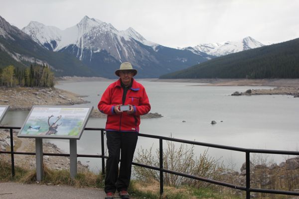
The drive from Pyramid Lake to Medicine Lake, which was on the other side of the valley, took about half an hour. After taking a picture of me at the site we spotted a Pileated Woodpecker (a first for us) and then walked down a path in front of the cache site where we saw some Chipping Sparrows as well as a pair of Common Merganzers. I noticed a large pile of very fresh bear scat so we quickly returned to the truck.
Here is my posting to the geocaching.com website:
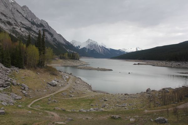
A very special Earth Cache for me. I worked on the construction crew that built the road along the side of this lake in 1964. Email to follow. Here are a few photos:
nosweat6060 at earth cache site
Medicine Lake at early spring levelI am 2/2 for today. When we returned to the Whistlers Campground I was able to access the Internet by tethering my laptop to my iPhone and emailed the originator with the answers to the questions. I received a reply from the individual within a few minutes.


