Feb17/2011 |
Geocache Activity 1006 |
FIND 928 |
IDENTIFICATION
Difficulty 2; Terrain 2; none; Creator: legna and sOulbAit Date First Hidden: 7/31/2009 Date Last Found: 02/16/2011 Description Old Spanish Quarry Earthcache The Castillo de San Marcos The great stone fortress, the Castillo de San Marcos, protected the town of St. Augustine, Florida for nearly 200 years. Spanish colonists built the fort from coquina rock quarried from Anastasia Island, including this site at Anastasia State Park. Without the rock, Spain might have lost St. Augustine, and Florida, as a colony. Or, the ancient town of St. Augustine might have been abandoned, left to fade from Florida’s history. The Monument site consists of 20.5 acres and includes a reconstructed section of the walled defense line surrounding the city of St. Augustine incorporating the original city gates. The Castillo de San Marcos' architecture and detail are distinctive and unique. It is the oldest masonry and only extant 17th century fort in North America. As such it is an excellent example of the "bastion system" of fortification. Quarry Historical Site Coquina rock links Anastasia Island to the charismatic architecture and history of St. Augustine. More than 300 years ago, Native American Indians, enslaved Africans, and the Spanish worked coquina quarries of Anastasia Island to construct the Castillo de San Marcos fortress. In Anastasia State Park you may take a short walk down a shaded and signed trail to view the site of these labors. When the quarries were active, St. Augustine (founded in 1565) was a struggling outpost of Spain’s American empire. Spanish soldiers built their homes and forts out of local pine, palm, and palmetto, but these wooden settlements were repeatedly destroyed or burned by pirates and raiders. Soon the Spanish discovered a better building material on Anastasia Island: coquina rock. Acquisition of coquina rock was difficult, but resulted in durable and solid buildings. The workers hewed out squares of the relatively soft, wet stone with hand-tools and loaded them onto carts. Oxen dragged these heavy loads to the water, where the blocks were barged across Matanzas Bay to the town of St. Augustine. Finally, in 1671, large-scale quarrying began in the stone pits. Anastasia Island was even called "Cantera", Spanish for "quarry". Early on, quarrying was limited by manpower, engineering skills, and money. In 1598 workers had cut out enough coquina blocks to build a gunpowder storage magazine. Finally, in 1671, the Spanish embarked on large-scale quarrying on Anastasia Island. At this time, the island was called “Cantera,” Spanish for quarry. The people of St. Augustine didn’t realize they had happened upon an amazing defensive material. As the soft stone was exposed to air, it hardened. The Spanish waterproofed coquina stone with plaster and paint, so the coarse rock structures you see today, such as the Castillo de San Marcos and city gates, would have looked more refined. However, when besieging ships bombarded the Castillo, the walls simply absorbed the cannon balls. The Castillo de San Marcos was never captured in battle, thanks in at least part to the rock made of tiny shells, coquina. Spanish, British, and Americans in turn prized coquina as a building material and went to great lengths to obtain it. By the late 1700s, Native American Indian populations were decimated and the Spanish primarily employed enslaved Africans to work the quarries. The quarries were not exhausted and today some coquina is still quarried commercially. Coquina rock is part of a sedimentary formation that underlies much of the Atlantic shore of Florida. The story of coquina rock begins in West Africa, where a similar rock formation is found. Coquina forms a sedimentary structure underlying much of the Atlantic shore of Florida, and geologists believe eons ago, before the continents drifted apart, these formations were connected. Sand and Donax variabilis clam shells accumulated when sea levels were higher and the area was underwater. Later, during a glacial period about 125,000 – 100,000 years ago, the sea level dropped. Rain dissolved calcium carbonate from the shells, cementing the mix of quartz and shells together into coquina rock. The word "coquina" means "tiny shell" in Spanish. It was the name they gave to the Donax variabilis clam that was abundant on the northeast Florida beaches. It is the predominant shell in the rock. Remember that this area is a protected historic site on the National Register of Historic Places and nothing may be removed from it. Hours of Operation for Anastasia State Park and Fort Anastasia State Park is open 8 a.m. until sundown, 365 a year, including holidays. You will not be accessing the paid area. The quarry is located out by the main drive into the park area. No fee is required to the quarry location, but you will have to follow the hours of operation. The Castillo de San Marcos is open to the public from 8:45 AM to 5:15 pm every day of the year except December 25. (The ticket booth closes at 4:45 pm.) The Park grounds are closed from midnight until 5:30 am. You will not be accessing the paid area. The cords for the fort are near the parking area. No fee is required to the above cords, but you will have to follow the hours of operation. To Claim Credit For This Cache: First requirement - Go to the following cords: N29 53.820 W081 18.710 (or general fort area). Then take a photo of yourself holding your GPS with the Coquina Fort in the background. You will need to post this photo to your log. Second requirement - You will need to visit the following cords: N29 52.805 W081 17.125. This will be a short drive from the fort. At this location you will find an information billboard and entrance gate to the quarry. You will need to take a photo of yourself holding your GPS with the (quarry information billboard or entrance gate in the background). You will need to post this photo to your log. Third requirement - For education purposes you will need to follow the path at the entrance gate down to the quarry. When you get there, you will need to use your GPS to get an estimate of the size of the quarry. (A) Let me know the approximant dimensions of the open quarry - LxWxD. (B) Let me know if this quarry was able to produce enough material to complete the fort or were other quarries needed. (C) Let me know the type of vegetation that is now growing in this area and why you think this type of vegetation is growing here. (Please email this information to us before logging this cache and do not post your answers in your log). The above requirements must be completed to properly log this cache. Both photos must be posted to the cache page at time of logging. Please do not post photos of the quarry. (Each cacher/family member - with their own caching name - must have their own photos posted to there log, duplicate photos or group photos will not be accepted). Special Thanks To: Mitch Clark - Park Ranger Geocaching.com for having Earthcache style caches. geoawareand Geosociety.org for making this possible. The Florida State Parks System and National Park Service for the information they supplied on the internet. Thanks to GatoRx for giving me permission to post this cache close to his own cache: (GCB34B) Navigation Navigation * log your visit * view gallery * watch listing * ignore listing * bookmark listing Remove from your FavoritesRemove from your Favorites Add to your FavoritesAdd to your Favorites 94Favorite points remaining Found ItYou logged this as Found on Thursday, 17 February 2011. Watching 5 user(s) watching this cache. Map not 24-7 restrooms available scenic view kid friendly parking available stroller accessible What are Attributes? Inventory Inventory There are no Trackables in this cache. View past Trackables What is a Travel Bug? Bookmark Lists * Spreading the Love Event found by Team Pita Puppets by flyingpita * Historical Geocaches of St Augustine by legna and sOulbAit * Nefga Earthcache Challenge by legna and sOulbAit View all 9 bookmark lists...
Hint Comments
PLANNING
I put a set of 4 geocaches in my GPS unit that were all in the central tourist area of St. Augustine. The idea was to try for these while touristing the main attractions.
OUTCOME
This was my 4th search of the day. I have a special liking for Earthcaches and was glad to find one of these while in Florida. Here is my posting to this geocaching.com website:
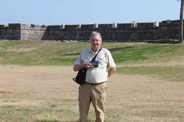
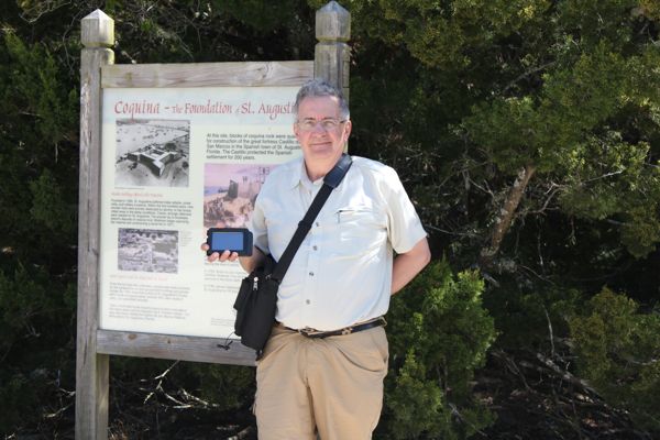
My favorite type of geocache. An email has been sent to the authors. Here are the two photos. Here are a few photos:
Nosweat6060 at the fort
Nosweat6060 at entrance to quarry
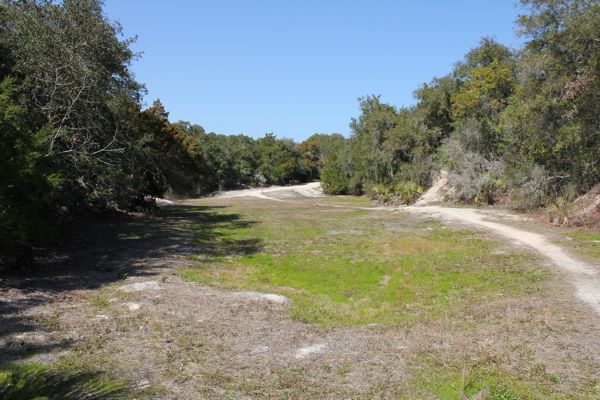
Quarry today
I am now 4/4 for today.
