IDENTIFICATION
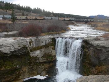
Difficulty 1.5; Terrain 1.5; size - not chosen. Creator: crossstitcher. Date First Hidden: Jul 2/07 Date Last Found: Sep 27/08. Description The Lundbreck Falls EarthCache is located a short distance from parking on generally flat terrain. Lundbreck Falls is formed where the Crowsnest River plunges over an erosion-resistant sandstone cliff of the Belly River Formation, deposited around 75 million years ago. This formation was deposited in a broad delta that bordered the western shoreline of the Late Cretaceous inland sea that covered much of Alberta. During this time, rivers flowing eastwards from the rising mountains in the west brought great quantities of sediment, particularly sand, and dumped them on the many deltas such as the Belly River Delta. The cliff that forms Lundbreck Falls contains numerous sedimentary structures, such as ripple marks and worm burrow traces, which indicate a shallow shoreline environment.
The Lundbreck Falls EarthCache is located on flat terrain with ample near by parking. To log this EarthCache please complete the following:
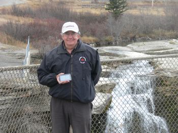
1. E-mail the cache owner (do not post) the approximate height of the falls and the number of distinct rock layers (include the approximate thickness of the layers distinguished by color) seen at the site. 2. E-mail (do not post) the cache owner the name of the feature found 200 - 300 metres west of the falls. 3. Post a photo of yourself with GPS in hand at the EarthCache site. Enjoy!
PLANNING
The weather is holding. I want to see if I can find the last "little green thing in a tree" in west lethbridge. Then we will drive west to Cowley where I want to look for 5 geocaches and exchange a few Travel Bugs.
OUTCOME
I have always enjoyed stopping off for a look at the falls and I am also enjoying the EarthCaches (this is my third).
An easy "find". I enjoy reading about the geology.