• Dr. Chris Hopkinson, Research Scientist, Applied Geomatics Research Group, Centre of Geographic Sciences, Lawrencetown, Nova Scotia.
• Ms. Allyson Fox, Research Associate, Applied Geomatics Research Group
• Mr. Tristan Goulden M. Eng. Department of Biological Engineering, Dalhousie University.
• Guest presentations from the lidar industry.
Summary:
This full day workshop will provide a comprehensive overview of airborne laser scanning (ALS) technology, operations and environmental research project applications. It is divided into two parts with frequent opportunities for interactive discussion. In the morning, we will focus on gaining a better understanding of what an ALS system is and how it works. The learning objective for the first half of the workshop is that attendees become familiar enough with ALS technology and applications that they know: a) when ALS would or would not be useful in answering particular environmental research problems; and b) what type of ALS technology would best suit a particular project. Examples of ‘off the shelf’ terrestrial, bathymetric and fluorescent ALS instruments and their uses will be presented. Some common data processing procedures, options and the tools available will be illustrated and discussed. The applications focus for the workshop will be environmental monitoring and natural resources assessment.
The afternoon will focus on real world ALS research project issues with a learning objective that an attendee is better prepared to define the scope of their own ALS projects while avoiding some of the problems commonly encountered. Topics covered will range from definition of scope of work and requests for proposals; mission planning; airborne data acquisition logistics; ground validation planning and logistics; data processing and output options; error assessment and reporting; and more. These topics will be introduced both explicitly and within the scope of real world case studies. Project and partnership examples from the last seven years of Canadian Consortium for Lidar Environmental Applications Research (C-CLEAR) activities will be outlined. The afternoon will end with a case study detailing an example of the consortium approach to research project partnership data collections across Canada.
Attendees can elect to take the full day or either half day of the workshop. Those attendees registering for the full day will receive a free copy of the book “Hydroscan: Airborne laser mapping of hydrological features and resources”, edited by Chris Hopkinson and Alain Pietroniro, and published in 2007 by the CWRA, CSHS and C-CLEAR. Half day attendees can elect to purchase a copy at the workshop.
Who should attend:
This workshop is intended for environmental scientists, natural resources researchers/managers/planners and those desiring a better appreciation for ALS and how high-resolution lidar data can be implemented in their projects. It is also intended for those wishing to better understand how they might partner on non-profit lidar research campaigns through C-CLEAR. Given the object of the workshop is to provide an overview of relevant material it is mostly at an introductory to intermediate level.
Biosketch:
Dr. Chris Hopkinson
Dr. Chris Hopkinson is a research scientist with the Applied Geomatics Research Group (AGRG) out of Nova Scotia’s Centre of Geographic Sciences (COGS). Chris is also the provincial branch past-president for the Canadian Water Resources Association, Atlantic Region Chair of the Canadian Remote Sensing Society, Chair of the American Society for Photogrammetry and Remote Sensing (ASPRS) LiDAR committee, an associate editor of the Canadian Journal for Remote Sensing, and the national coordinator of the Canadian Consortium for LiDAR Environmental Applications Research (C-CLEAR). He manages international airborne and ground based LiDAR contracts and logistical operations for AGRG and C-CLEAR. His research efforts currently focus on investigating LiDAR error propagation and developing LiDAR technology for water resources and forestry assessment applications. Chris’ water resources research has focused mostly on hydrological interactions in mountainous environments and glacial contributions to river flow in western Canada. In Nova Scotia, he has led a number of water resources, flood impact and biomass mapping projects in. While teaching a post-graduate advanced diploma LiDAR curriculum at COGS, he also regularly hosts LiDAR seminars and workshops at various conference venues, and has directed university lecture courses on hydrology, meteorology, drainage basin ecosystems and earth systems science.
Tristan Goulden, M.Sc.
Tristan Goulden is from Wolfville, Nova Scotia and began post-secondary education of the Centre for Geographic Sciences where he obtained a diploma as a Geomatics Engineering Technologist. He continued his education at the University of New Brunswick earning a Bachelor of Science in Geodesy in Geomatics Engineering. After a brief hiatus into private industry Tristan began work as a research intern with the LiDAR team at the Applied Geomatics Research Group (AGRG). At AGRG he began work on error modeling and error analysis of airborne LiDAR observations. In addition to theoretical research into LiDAR, Tristan gained practical experience by participating in LiDAR campaigns in the southern United States and Western Canada. This work initiated a return to the University of New Brunswick where he obtained a Master’s of Science in Geodesy and Geomatics Engineering. The Master’s work produced a thesis which focussed on analyzing error in LiDAR observations in sloped environments, with particular emphasis on alpine glaciers. Currently, Tristan is pursuing a PhD at Dalhousie University where he plans to focus on improving the geo-referencing capabilities of Fluorescent LiDAR technology.
Allyson Fox, B.Sc., Dip. RS(Hons)
Allyson Fox, originally from Fort St. John, BC, holds an Honours Geography degree in Environmental Studies, with a specialization in Biophysical Systems, from the University of Waterloo. After working in education for seven years, she returned to school, attending the Centre for Geographic Sciences at the Nova Scotia Community College (NSCC), earning an Advanced Diploma, Honours, in Remote Sensing. Following graduation, Allyson completed a six month internship at the Applied Geomatics Research Group (AGRG) at NSCC, under the C-CLEAR initiative with Dr. Chris Hopkinson. This experience provided the opportunity to continue working at the AGRG as a Research Associate with the Lidar operations team. She coordinates with research scientists on LiDAR surveys, is involved in mission planning, and in operations on field campaigns which have taken her to Peru, Western Canada, the Yukon and NWT and locally in Nova Scotia. She works extensively with advanced processing of LiDAR data to support research endeavours. Allyson also participates in education and outreach as part of AGRG’s applied research activities.
Prior delivery of materials:
This workshop is an updated and evolved version of prior conference workshops hosted at the following venues:
ESRI
IGARSS
GeoTec
CWRA
Hydroscan
Geomatics Atlantic
Several other smaller events and stand alone workshops
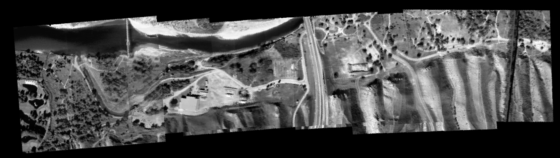 Image mosaic of Lethbridge coulee landscape - UofL MARSS imaging system