Introduction
Sonification of data is the rendering of sound from data that contain no native acoustical signal. Given the wide array of data possibilities, it comes as no surprise that sonification projects are often interdisciplinary in nature. For this project, the combination talents in the musical/visual arts and natural s ciences were used to create interesting musical compositions from satellite image data.
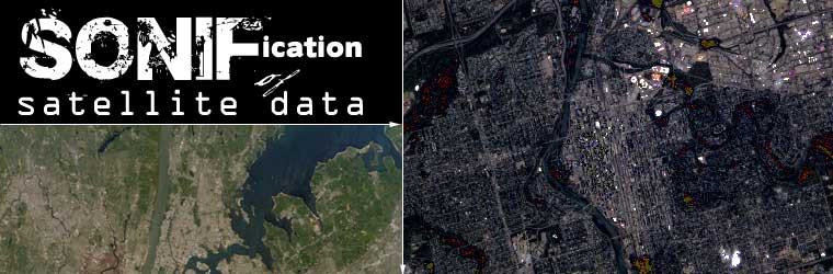
Vast quantities of satellite imagery of the earths surface are collected on a daily basis. The analysis of these data is a complex combination of visual interpretation and digital image processing. Scientists studying the data from these images are primarily focused on retrieving the information they contain in a static image-processing environment. These images provide us with not only data about the planet, but have an aesthetic appeal that is often overlooked. The overhead view provided by these satellite images present our world from a unique perspective. Our natural and human-modified landscapes create interesting visual shapes, arrangements, and patterns on the landscape. This research was focused on different ways of interpreting our places. We examined a variety of different visualization techniques in conjunction with data sonification to explore what satellite images sound like.
With the ever-increasing volume and variety of complex data and the advent of multimedia technologies, sonification is beginning to play an increasingly important role in data exploration (climate change data, human genome project, etc.). The vast quantities of information produced by modern instrumentation open up a wide variety of interests in new representations of this information. The motivation for this project was to explore the use of satellite imagery as a source of data for creating musical compositions. While composers of music have always used landscapes as a means of motivation, we wanted to explore the ways that landscapes, by using satellite data and sonification tools, could create their own sound.
Sonification Process
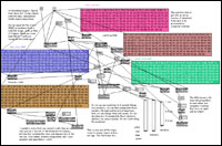 |
| Figure 1. A subset of the Max/MSP score for "Spiral from Nose Hill", showing the complexity of the object-oriented programming. (click for larger picture) |
The sonification of the satellite data was performed in Max/MSP. Max/MSP is an object-oriented programming environment that allows for a wide range of flexible options for the transformation of data into sound. In the crafting of the musical pieces, values like the transect coordinates and the spectral bands from the satellite imagery were used to drive different sonic parameters. The end result was designed to not only present the data, but to convey a sense of place through sound.
The creation of a sonically pleasing rendition of satellite data requires a lot of creativity and programming. Figure 1 shows a small portion of the Max/MSP score for one of the movements. In Max/MSP objects are linked by virtual "patch cords" that allow for data input, control of temp, mathematical transformations, and control of every possible musical parameter down to the millisecond. Not for the faint of heart.
In creating this sonification experiment, we were seeking to transcend the new, the news, the trend, the latest and the greatest, the right now, or the buzz. Of course humans are interested in non-mundane things, that is a given. This always has been and will always so be. The end goal was to present the listener with an experience that transcends the newness of the sound and enables them to identify with it. In this sense, music created using satellite data can present a geography of sound that can it strike a chord for the listener.
Audio
Windows Media Player required to play audio files.
Each file is at least 1mb in size.- "What Wonderous Land is This?" part one of "Through the Fog to Halifax"
- Getting Done the Business of West, Central, North, and East" part one of "Drumming Ottawa"
- "Westside" part two of "Singing Lethbridge from the Sky"
- Approach from the Mountains" part two of "re-Sounding Calgary"
- B" part two of "Ten Degrees Northeast of Okotoks"
- Parks Along the River" part three of "Spinning Sound from Edmonton"
- Got Places to go" part one of "Vancouver Jazz from the Milky Way"
Visuals
Quicktime Player required to view video files.
Singing Lethbridge from the Sky: Created by Craig Coburn and A. William Smith. Resounding Calgary: Created by Craig Coburn and A. William Smith.- Nosehill [18mb]
- Approach from Mountains [16mb]